
Public policy should be spatially legible: expert testimony from SKCCH vs. Burien
Imagine that you are homeless in Burien, without a working cell phone, and trying to camp for the night in the public right-of-way along this street:

Picture of Southwest 132nd Street at the intersection with 8th Place Southwest in Burien, facing west. Street View image © Google 2025.
For most of 2024, overnight camping was legally permitted along half of the public footpath on the right side of this image, and it was banned on the other half. Can you guess which half is which?
In 2024, the Seattle/King County Coalition on Homelessness and the Northwest Justice Project sued the City of Burien on behalf of three unhoused plaintiffs, arguing that Burien’s anti-camping policy effectively criminalized homelessness within city boundaries. The policy in question was Ordinance No. 832, passed by Burien City Council, which prohibited camping in the public right-of-way within 500 feet of select city amenities even when no shelter beds were available. A map showing camping ban areas was included with the ordinance:
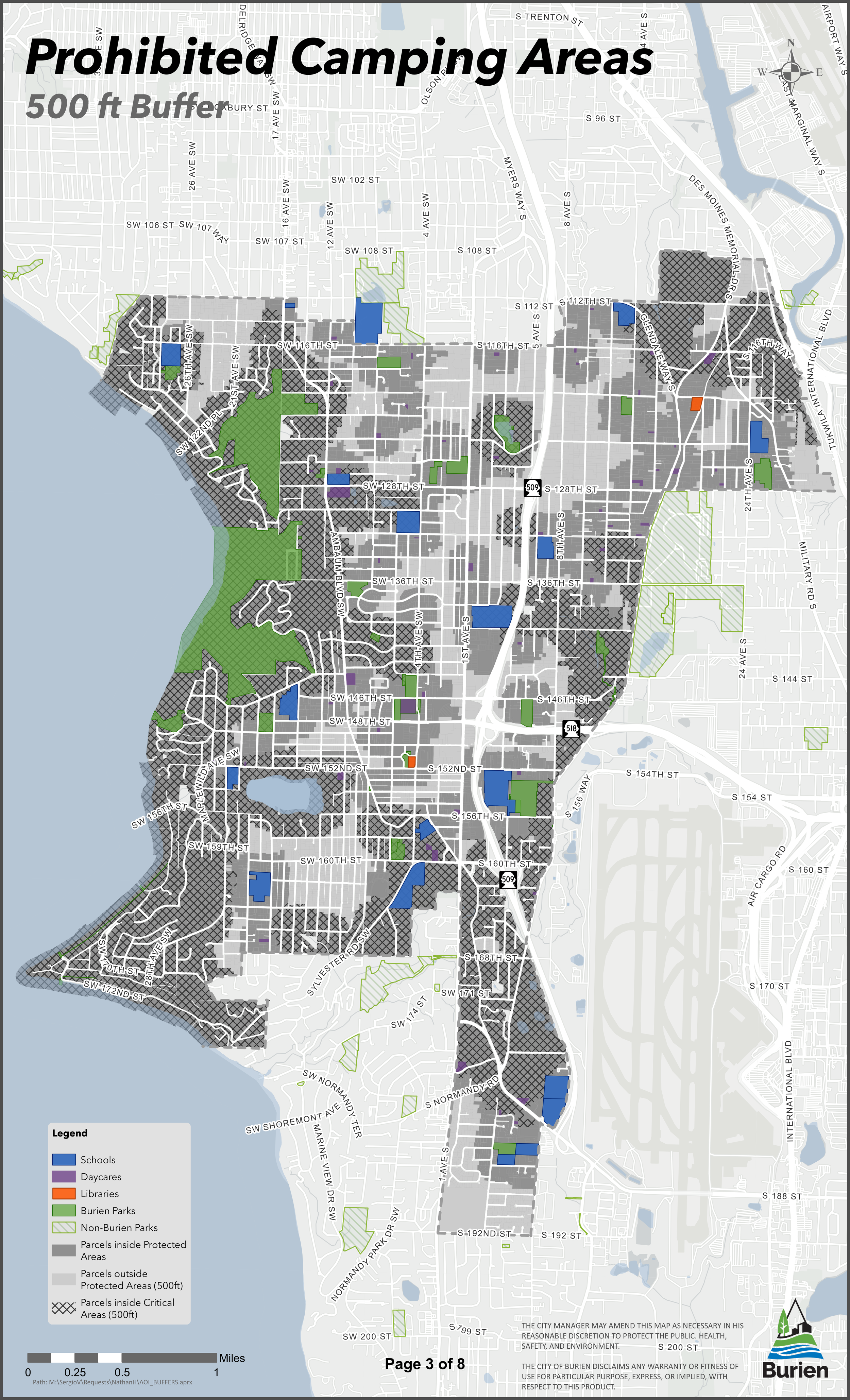
Map attached to City of Burien Ordinance No. 832, March 2024
I served as an expert witness for the prosecution in this case, evaluating the area covered by Burien’s camping ban as well as the legibility of ban maps published by the City.
By carefully reconstructing the City of Burien’s map from government and open data, I found that the camping ban covered 81% of Burien’s land area. Of the roughly 21 linear miles of sidewalks across Burien, only 1.1 miles of sidewalk (5%) were outside of the camping ban area and had a recorded width greater than six feet.

Burien camping prohibition map reproduced by Henry Spatial Analysis
Furthermore, the map published alongside Ordinance 832 was unsuitable as a reference for distinguishing locations where camping was or was not banned:
As shown in insets A and B below, street name labels obscured the ban status of some parcels.
Because the map’s background color was a similar shade of light gray as parcels outside of the camping prohibition zone, some areas in the prohibition zone erroneously appeared to allow camping under Ordinance 832. This is shown in insets C and D below.

Details from the City of Burien camping prohibition map. Dotted red lines highlight areas on the map where street labels obscure the prohibition zone boundaries. Dotted yellow lines highlight parcels that were missing from the map; the light grey background could cause confusion about whether these parcels fall inside the camping prohibition zone.
The City of Burien eventually published an interactive web map showing the camping prohibition zone. However, even with an internet-enabled device, a camper (or police officer) could still easily misinterpret the ban status of nearby rights-of-way due to errors in GPS location.
This reveals an underlying issue with the policy’s spatial legibility: the camping prohibition zone’s borders were so complex that they invited mistakes on the ground.
For example, the following map shows the camping prohibition status for the street segment at the start of this post according to Ordinance 832:

Camping prohibition map detail around Southwest 132nd Street, showing a possible example of user misinterpretation.
Here is the same camping prohibition status visualized at the street level:

Camping prohibition status for the right of way along Southwest 132nd Street. Orange indicates right-of-way segments where camping was prohibited under Ordinance 832. Street View image © Google 2025.
It was my expert opinion that an average map user would find it difficult to identify public parcels and sidewalks that fall outside of the camping prohibition zone using the maps provided by the City of Burien. You can read my full declaration here.
Following the Grants Pass v. Johnson Supreme Court ruling, the City of Burien issued a revised ordinance that banned camping citywide in January 2025. Nevertheless, Burien’s short-lived attempt at a map-based ban highlights the need for spatial legibility in policymaking, especially when those policies concern vulnerable residents.